August 24th, 2015
Danny has weakened to a tropical depression and may well dissipate within the next 72 hours. The storm is being sheared apart at higher altitudes. Even though the NHC is no longer publishing Danny’s exact position, the NHC is still providing a track of the storm. This track brings Danny south of Hispaniola by Wednesday, after which Danny will become a remnant low.
East of Danny, at 43 degrees west, is another storm, designated 98L. This storm has a very high probability of organizing, and might be declared as a tropical depression or storm sometime today. Its track is more worrisome than Danny’s, in that it’s forecast to curve towards the north just east of the U.S. coast. An average of the five models used show 98L passing us in about eight days at a distance of about 200 miles. If 98L is designated, it will be named Erika.
Posted in Tropical Weather News | Comments Off on TD Danny and 98L
August 19th, 2015
I meant Danny … Tropical Storm Claudette menaced the east coast of the United States and Canada in mid-July. Sorry for the error.
Tropical Storm Danny, formerly Tropical Depression 4, is still traveling in a westward direction in the tropical Atlantic at about 12 MPH. As of the 11 AM advisory, Danny had winds of 50 MPH and a central pressure of 1000 MB. Even though TS Danny is looking pretty ragged on satellite, the storm has a good core structure and shows signs of continued strengthening.
The storm’s track and eventual strength depends upon whether a trough to its north. If the trough is strong enough, Danny will move more westward and lose strength. If not, Danny will start its curve. We’ll have to wait for a few days before the fate of Danny becomes clear.
Posted in Tropical Weather News | Comments Off on Did I say Claudette?
August 18th, 2015
As of 11 AM, the NHC upgraded storm 96L to tropical depression status, with the new name of TD4. The storm has winds of 35 MPH and a central pressure of 1009 MB. It is moving towards the west at 13 MPH, and is at least a week away from land. The current track has TD4 curving slightly towards the south on Friday, putting the storm on a course south of Cuba.
As to intensity, the storm is forecast to be upgraded to a tropical storm later today, and a hurricane by Friday. If TD4 does become a named storm, it will be named Claudette.
Posted in Tropical Weather News | Comments Off on Tropical Depression Four
August 18th, 2015
For the last several days, storm system 96L has been gaining strength and trying to organize. Today might be the day. Storm 96L currently has winds of 30 MPH and is about ten days from the Georgia coast, assuming its eventual track leads it here. According to the NHC the storm had a 90 percent chance of becoming tropical sometime today.
The tracks on this storm, provided by Weather Underground, have trended a bit towards the north since yesterday. It’s looking like this storm might be a coastal one, rather than a Gulf storm. Again, ten days away.
Posted in Tropical Weather News | Comments Off on 96L
August 9th, 2015
About an hour ago I began a thread of posts in the decidedly non-threaded Facebook environment. Here’s the issue: Columbia Pictures just released a film named Pixels.
Columbia Pictures and the MPAA have hired an anti-piracy company to help protect the investment of the film. But, apparently the anti-piracy efforts have been too aggressive, shutting down indy film makers who have similarly named content, but does not infringe in any way upon the film.
In response to this, I have created a short file named Pixels.wmv and have uploaded it to both YouTube and my HUD-1 Web Site.
This short indy film is not intended to compete with, infringe upon, or profit from, the Columbia Pictures production of the film Pixels.
Posted in Tropical Weather News | Comments Off on Pixels
August 4th, 2015
At 6:53 PM, the local NWS station, KSSI, reported a barometric pressure of 1010.6 MB. That was the lowest pressure reported yesterday, so I presume it was when the center of disturbance 95L was as close as it would be.
This will be my last post regarding 95L unless there are repercussions for Saint Simons from this storm. I don’t anticipate any, but you never can tell.
Posted in Tropical Weather News | Comments Off on 95L Passed at 6:53 PM
August 3rd, 2015
Over the last few hours, the tracks for 95L has been trending eastward. As of the 2 PM track, the exit point of the disturbance was coastal Glynn County. the estimated time was around 8 PM. The general movement of the storm system is at 5 MPH towards the northeast, but from tracking records, either the storm has stalled or the center keeps jumping around.
Since I can’t trust these tables and track maps, I’ve decided to trust my eyes. Here is a radar image of the area.
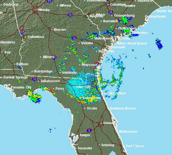
As you can see the center appears to be southeast of Waycross. It might get lost again, or stall out again, but eventually it will reach the Atlantic coast.
Posted in Tropical Weather News | Comments Off on Radar of 95L
August 3rd, 2015
The disturbance over Florida has been given a designation of 95L. As of 8 AM, 95L was forecast to travel from the Big Bend area of Florida in a general northeasterly direction until it enters the Atlantic. The computer models are a bit confused about the timing, but not the course. There is good agreement that 95L will pass west and north of Glynn County sometime this afternoon or early evening. The models indicate that 95L has winds of 30 MPH, but I can’t find a central pressure.
As to how much threat it poses … I have no idea. The storm should bring us some rain, but I’d be ready for other threats, such as heavy winds and tornadoes. Our local weather is showing a 40 percent chance of rain this afternoon and evening. It has also been my experience that a feeling of oppressive, still air and high humidity is possible.
Posted in Tropical Weather News | Comments Off on Disturbance 95L
August 2nd, 2015
July was the quietest month I can remember since I moved here over 20 years ago. There were only two tropical waves that looked as though they might strengthen, as well as one disturbance just off the Florida coast. That might be changing.
As of 2 PM this afternoon, the NHC began tracking a new disturbance in Apalachee Bay, about 40 miles south of Tallahassee, Florida. This disturbance has only a ten percent chance of further intensification; however, its course is towards the northeast in the general direction of NE Florida and SE Georgia. In other words, coastal Glynn County. There is no track maps to show how fast the disturbance is moving.
As of 5 PM, the official forecast for Glynn County showed a 70 percent chance of rain. The point forecast has not yet been updated to cover the expected conditions, so there is no way to tell how much rain we will get before tomorrow. Seeing the local radar, I’d say we’re already under an outer rain band, and will have quite a lot of rain this evening, along with the usual chances of strange winds, tornadoes and heavy surf.
Posted in Tropical Weather News | Comments Off on New Disturbance Forming Over Florida
July 12th, 2015
A disturbance just off the North Carolina coast has shown signs of organization this morning. Although I can’t be certain, it looks like 92L began as one of the storms that slammed through the northeast late last week. 92L is not a threat to the Georgia coast. Maine and Newfoundland might get a hit in a few days.
As of 8 AM, 92L had winds of 25 MPH. The NHC has given the storm a 20 percent chance of further organization.
Posted in Tropical Weather News | Comments Off on Invest 92L